This was it. The goal of the year. The trip we had essentially built the entire vacation around. We were going to backpack to Eagle Cap.
Eagle Cap is a big half-dome looking peak almost smack dab in the center of the entire Wallowa range. It's 9,572 feet high, and it's about the 7th highest peak in the Wallowas. The highest peak, Sacajawea Peak, is roughly only 300 feet taller. It's the centerpiece of the range and the most popular mountain (to backpack to, Mt. Howard likely gets far more visitors due to the tramway). Due to it's location deep in the middle, day hikes are sort of unlikely, as the entire trip would be 20 miles and 4,000 feet of elevation gain. Possible, but that is a long day. That's why most people backpack it. Like us!
We got our packs ready and were on the trail by 8. The trail to Eagle Cap can be split into effectively 4 even sections. The Alpine forest climb, the Lostine Meadows, the Alpine climb to Lakes Basin, and the final steep exposed ascent. Luckily, everyone camps at Lakes Basin, so we didn't need to carry our packs all the way up Eagle Cap, just the 7 miles to Mirror Lake. Then we could drop off all the weight and just take water and cameras up Eagle Cap.
 |
| (K) Our start point |
 |
| backpack is bigger than her torso |
 |
| Starting our long journey |
Mile 1.
The first section of the trail in the alpine forest starts out almost casually in the woods. Tall trees mostly block the view of everything. You get vague hints of the valley walls, but nothing substantial. The trail from the parking area is actually split, you can take the right or left path. We took the left. After maybe 1/5th of a mile, the two converge, and the real split occurs. To the right a trail follows the Lostine River up to Minam Lake. To the left, it follows the East Fork Lostine River to Lakes Basin. We kept left. After the junction you start to climb a bit. The trail is rocky and dusty, you need to watch your footing. After almost exactly a mile, you come to a log bridge. I dubbed it One Mile Bridge. You cross over the East Fork Lostine and start climbing up the west side of the valley.
 |
| One mile bridge |
Mile 2. After 1 mile bridge the trail flattens out for a while. You continue to get hints of the majesty of your location through the trees, and occasionally a landslide area will provide some exposure. We saw a lot of wildflowers and butterflies here. After over half a mile of mostly flat, gentle climbing, the switchbacks hit. The trail steeply switchbacks up 11 times, and they are merciless. On the 2nd switchback the sky opens up and you finally get to have a true appreciation of where you are, looking north to the end of the valley. We took two breaks to alleviate our 30 lb backpacks, and I was thankful for my pasta dinner the night before. If you don't eat properly, this section will murder you. It's the steepest part of the trail and you climb about 1000 feet in a half mile or less.
 |
| Flowers & butterfly |
 |
| Our first real view looking north to the end of the Lostine River Valley |
 |
| The 6th switchback, where we had to take a 10 minute rest. It's this crap for half a mile. |
Mile 3: Mile 3 starts near the end of the switchbacks. Thankfully, once you get past the switchbacks, the hard part is over. Soon things level out a bit and you come to a pretty cascading waterfall. We took a quick break, climbed up the final steep section to get to the top of the waterfall, and continued. Near the end of the mile the meadows start to show up. You get more open views of the valley, but you still can't see Eagle Cap to the south. The trail begins to split again around here, as a lot of people camp in the early meadows. You can take any trail, they will all eventually lead back. We finally took a trail into the meadows, and it was beautiful.
 |
| (K) waterfall on mile 3 |
 |
| Meadows |
 |
| Eagle Cap? Way back there! |
Miles 4-5, part of 6: Mile 4 starts pretty much with your first views of Eagle Cap. You get faint views of it through the trees, and then it opens up, into full blown meadow, and you see everything. The hike instantly becomes worth the pain. The valley is shaped like a big U, thanks to glaciers long gone. In the middle of the U the East Fork meanders around grassy meadows. Rocks and trees line the walls most of the way up. Red flowers and green grass cover the meadow. Butterflies flicker around. Ground squirrels hop around, stand up on their hind legs and look at you, or make squeaky noises. Pikas are hard to find as they live in the rocks and are the size of mice, but you hear them cheeping too. It's pretty much a mountain paradise. You spend the majority of these miles walking a mostly flat (or very gentle hill) trail on the far west side of the meadow. Eagle Cap and it's little ledges creep ever closer, but never feel real and always have that postcard quality. Near the end of the meadow you finally cross it, going over the river on a nice bridge. Then you enter the 3rd stage of the hike on the east side of the river.
 |
| Eagle Cap in all it's glory |
 |
| Eagle Cap through the trees |
 |
| Still about 5 miles away and 3,000 feet up |
 |
| Tiny alpine lake in the Lostine Meadows |
 |
| Keeley on the trail |
 |
| It's all worth it walking with that in the background |
 |
| The trail for 2 miles is pretty much exactly this |
 |
| Getting closer |
 |
| Crossing the Meadow |
 |
| (K) me on the trail |
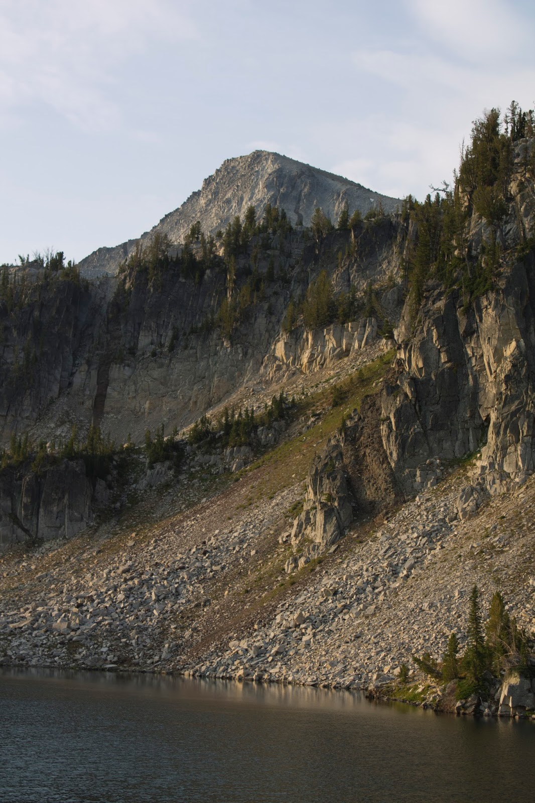
Miles 6-7: The alpine forest returns and so does the climbing. At this point there wasn't much to see or say, and we were starting to suffer. Conversation ceased as we just focused on putting one foot in front of the other. There were more switchbacks, but they were gentler than the earlier ones. For about an hour neither of us said a thing, just huffed and puffed. I could feel a blister forming on my right heel. My hips were killing me where the weight of the pack sat. Finally, finally, we came upon a sign that indicated we had entered the Lakes Basin area (A high point in the valley that holds a lot of glacial apline lakes, and it looks like Yosemite with big slabs of granite on the ground everywhere). We came across two park rangers fixing a sign, and they showed us that we had made it to Mirror Lake. Thank god. Lunch time. It was 11:30.
We walked down to the shores of Mirror lake, dropped off our backpacks, and ate some energy bars and drank water. I set up the tent on a nice smooth spot on a rocky cliff by some trees, and we got to look over Mirror Lake. It was beautiful. It reminded me of Hetch Hetchy in Yosemite. All around us was the big amphitheater walls of the valley and faintly over the top of the hills we could see Eagle Cap, still looming. Still impossibly far away. We stuck our feet in the lake to cool them off, I did first aid on my blister. I took a nap in the tent. Keeley learned how to use our water filter and filled our water bottles, At about 1:30, we were ready. We had 6 miles to go, 3 up to Eagle Cap and 3 down. We had another 2,000 feet of elevation to climb. It wasn't going to be fun.
 |
| Mirror lake from our camp |
 |
| (K) me by the lake, resting my feet |
 |
| Keeley looking at the lake |
 |
| Go Tigers |
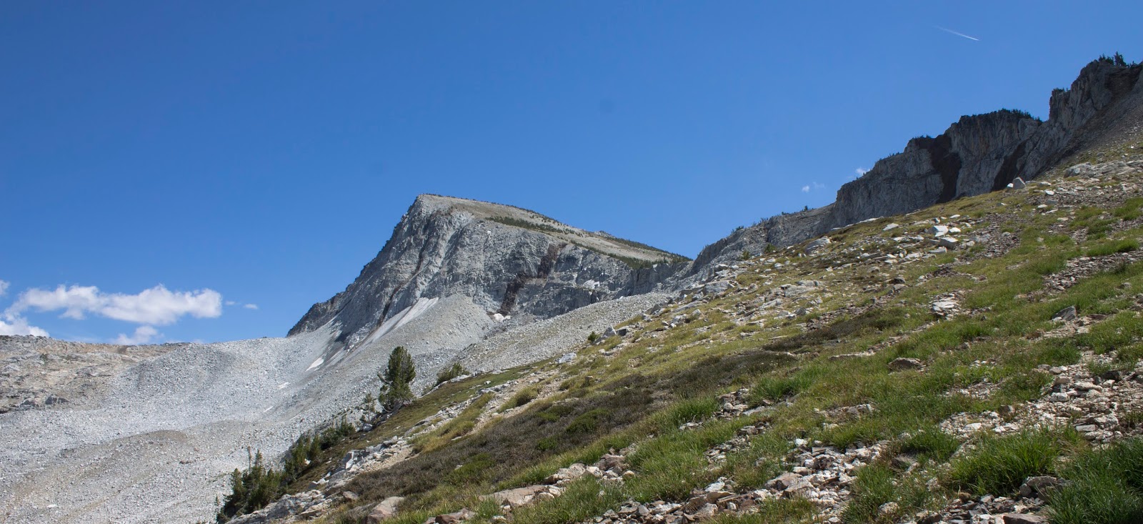
Mile 8: From lakes basic you wander across the meadow towards the big wall between you and Eagle Cap. next to a smaller lake the climbing begins. Up and up and up, steeper than anything on the trail thus far. You climb up this gap switch-backing for a full mile before you reach the lower plateau and get the first big view. The Matterhorn (Named because the Wallowas are considered the Alps of Oregon) looms to the north. Eagle Cap finally feels tangible and close, and somehow more frightening and still impossibly huge. The view is already worth it and you could reasonably turn back here, but it gets better. Much better.
 |
| Looking back at the Lostine river valley as we begin our trip up Eagle Cap |
 |
| Upper Lake and the Lostine River Valley |
 |
| The plateau and the incredible view north. The Lostine Valley (our path here) is to the left, and that giant white slab in the middle is the Matterhorn of Oregon |
 |
| Taking it all in |
 |
| Still have so far to go to the summit of Eagle Cap |
 |
| The Matterhorn |
 |
| (K) proper lableing |
 |
| Eagle Cap (upper right) watches over the lakes basin and valley areas |
 |
| Enjoying a break from the climb to that peak behind me |
 |
| Probably one of my favorite pictures I took the whole trip. Eagle Cap. |
Mile 9: From the lower plateau you resume climbing up a very exposed side of cliff towards Horton pass. While it's not certain death off the trail, a tumble would leave you sliding for quite some time. Eventually you crest the ridgeline that heads towards Eagle Cap, and the view essentially doubles. Over the crest you can now see everything except due east, which is still blocked by Eagle Cap. It was at this point Eagle Cap stopped being one of the best hikes I've ever done and became the hike all others will be compared to for likely the rest of my life. I can't describe it. I've been amazed and wow'd by views a lot. I've only been rendered speechless and had my mind blown a handful of times:
-My first full view of Crater Lake
-My first view of Yosemite Valley
-Glacier Point in Yosemite
-The Grand Tetons in the morning sunrise
-Hells Canyon, the previous day
This was better than all of it. Yosemite Valley is an amazing view, but only from the right angle. Glacier Point is an amazing view, but it's a little over a 180 degree view at best. This was almost a full 360, and it was like looking into 5-6 different yosemite valleys and hells canyons. No picture featured here will do the place justice. It can't. The scale of everything is lost. The bottom line is this is unquestionably the most amazing view I have seen in my entire life. Best of all, we were pretty much alone. For how "popular" this area is supposed to be, we saw maybe 30 people the entire time we were out for these 2 days, on a summer weekend during peak season. There is no crowd in the way most people would see one. Isolation is extremely easy to find. I was looking at something more beautiful than anything I'd ever seen, and it felt like a secret place that only locals could possibly know about. It doesn't make sense how something so stunning could feel so wild and unknown. This could easily be a National Park but is merely a National Recreation area. It's tucked away in a place you'd never find it if you weren't looking. It's perfect and is now my favorite place on the planet.
Mile 10: The final mile is mostly up the dome to Eagle Cap's summit. It's the final challenge and it sucks. If it wasn't for the view it would be miserable, but the view makes it almost fun, because it gives you an excuse to just take frequent breaks and look. Eventually, you reach the summit. You can finally see to the east, and it just adds to the already outstanding view. You are in the middle of the Wallowas, you can see everything. Joseph is faintly visible to the north. The Lostine River Valley that you hiked to reach this point sits in a beautiful socket to the northeast. hidden mountain lakes surround you in all directions. Tall, bare, red rock topped mountains rise around you. Stunning gaping valleys lie below. I could see Mirror Lake and our campsite, 2000 feet down.
 |
| Our path in was most of this valley, the Lostine River Valley |
 |
| Zoom in on the Lostine River meadows |
 |
| The view South |
 |
| Panorama of the view south |
 |
| Panorama of the view North |
 |
| South east |
 |
| From left to right: Lostine River Valley, Mirror Lake (our campsite) & lakes basin area, Hurricane Creek valley and The Matterhorn, then the West Fork Wallowa River valley, Joseph in the tiny speck of flat, and Mt. Howard/East Peak/Aneroid mtns on the far right. |
 |
| Glacier lake and the view east. Tiny Keeley on the Summit |
 |
| Keeley on the summit |
 |
| Summit hooray |
 |
| Zoom in on Mirror Lake. Our campsite was right on the rock ledge in the middle of the picture |
 |
| The Matterhorn & Hurricane Creek Valley |
 |
| The view south, west, and well pretty much at least 180 degrees facing about due west |
 |
| South |
 |
| South |
 |
| Final panorama from the summit. |
At this point something I'd planned for months was about to happen. I stuck my camera on a rock, secretly set it to film mode, walked over to Keeley and pulled a small box out of my pocket that I'd secretly been holding onto the whole time. I told her I wanted to ask her something, then before she could guess what was happening, I was down on one knee. I'll skip the emotional aspect, she said yes. We go hiking together all the time, and these moments are important to our relationship, so I wanted to do it during a special hike, and this fit the bill. I also told her I wanted her to have the most badass proposal story, so I figured 10,000 feet up in the middle of a glorious mountain range was the best place to do it.
 |
| The ring |
Eventually a park ranger joined us and we chatted with him about the area, and another group came up and we all took pictures. Eventually we decided to head back down, from this point all our travelling was downhill. It took us a while to reach Mirror Lake again, and for our first post-engagement dinner we struggled to work a camp stove to boil water and then ate surprisingly delicious freeze dried spaghetti & meatballs. I wanted to watch the sunset but clouds had decided to move in, and after 13+ miles of hiking we were toast, and we fell asleep by 8.
 |
| Eagle Cap over Mirror Lake, the reverse shot of my zoom from the summit. |
 |
| Mirror lake sunset, Eagle cap looming above |
 |
| Sunrise Panorama |
We woke up at 6, packed up, admired the sunrise, ate some gross oats, refilled the water supply, and said goodbye by 7:30. We were back in the parking lot by 10. We drove back to Enterprise for one last burger at Terminal Gravity (3 meals in 4 days! You're welcome, TG) then began the long, tiring journey back to Portland. We had to get to REI to drop off our rentals by 7, we got back at exactly 6:30, right in time. We took showers and went to sleep, the best vacation I'd ever been on finally over.
 |
| Sunrise |
 |
| Our camp at sunrise, and my favorite photo |
 |
| Eagle Cap |
 |
| heading home |
 |
| it was little more overcast heading back |
 |
| Last view of the meadows |
 |
| goodbye Eagle Cap |
 |
| beyond this spot it's just woods till the car |
 |
| Goodbye Wallowas |
 |
| I'll miss you |
 |
| Eastern Oregon in a nutshell |
 |
| The Blue Mountains |
This was the best vacation I've ever been on. I've seen Yosemite, Crater Lake, Yellowstone, Acadia, and countless other magical places (with many more to come!) and this is the best thing I've ever seen. Every trip I ever go on will be compared to this. Every hike I ever do will be compared to backpacking Eagle Cap. Every view I ever see will be compared to what I saw on the summit and at Hells Canyon. It had everything I wanted, even before the proposal. I don't know where we will go next, but it's going to be so hard to top this experience.
The Wallowas are one of the best kept secrets of the west, almost to the point where I hope no one reads this, because they should stay that way. There is so much to do out there, and we are going to go back. Lots more Hells Canyon to see, plenty more backpacking to do within the Eagle Cap Wilderness. It's a special place, and I already miss it, even though I'll remember this trip for the rest of my life.