Wauna Point is a large knife edge rock outcropping far above Bonneville Dam between Tanner Creek and Eagle Creek. It's tough to get to, and dangerous when you do. It had only been 5 days between our Labor Day 10-mile almost 4000 foot climbing fiesta at Rock of Ages, and we decided to do something ridiculous again. Wauna Point was 10 miles, and we gained 3400 feet total of elevation.
Strava Data
https://www.strava.com/activities/390857426
Wauna Point is basically the exact same hike as
Indian Point, just on Hard Mode. The similarities are almost creepy. Let me describe the hike to Indian Point:
-Travel short distance on the Gorge trail #400
-Go under power lines, start going parallel to a creek (Herman Creek), on a wide former road
-Reach junction, take left, start climbing
-Travel several miles through beautiful old growth forest with little to no views, on a uphill that is neither easy nor hard
-Reach top of ridge, take unmaintained sketchy path down to dangerous rocky outcrop with killer views
-From here either go back the way you came or go up the ridge to a cutoff trail and come back down to the forest road junction, then take the final leg back to your car under the power lines and on the 400
Now here is Wauna Point:
-Travel 1 mile on Gorge trail 400
-Go under power lines, link up to old former forest road, parallel to creek (Tanner Creek)
-Reach junction, take left, start climbing
-Go up through beautiful old growth forest with few views, on an uphill that is neither easy nor hard
-Reach top of ridge, take unmaintained sketchy path down to dangerous rocky outcrop with killer views
-Either go back the way you came, or keep going up ridge to cutoff trail which leads back to the forest road junction, go back to car under power lines and 400.
It's thematically literally the same goddamn hike, only on a higher difficulty level. You are on the 400 for a longer period of time, you are on the road for a longer period of time, the old growth forest section is also longer and now features a few switchbacks, and the rocky outcrop is more dangerous and harder to get to. On top of that, making a loop up the ridge is significantly longer, which we didn't do this time. The entire Indian Point loop was 8 miles, we didn't do a loop to Wauna and it was 10. Significant difference.
This all just means it's also still a great hike, and very very solitary. We got out there at 9:30 on a saturday (Slightly early but not unreasonably early) and only passed 3 people on the whole trip. This is another great long hike for locals to enjoy without tourists, as no tourist is going to randomly find their way up here. The more I hike, the more that tourists annoy me, so this is a good thing.
We parked at Wachella Falls trailhead, but instead of walking to Wachella falls, we walked back up the road right to the intersection with the exit ramp, where the trail starts. Now we were on the 400 and the climb began. This section of the 400 isn't steep but it's steeper than most sections of this trail, and after a couple switchbacks we were a few hundred feet up. Then the trail headed east, overgrown and spider-filled (this must be spider season they are EVERYWHERE) and eventually we passed under some power lines directly leaving Bonneville Dam. We got a slight view of Table Mountain here.
A very short distance later, the 400 intersects Forest Road 777, a now closed road up to the Tanner Creek area. Turn right and walk back under the power lines, heading up the road. At one point you'll see the remains of a recent mega washout coming down from the left.
 |
| This sign was not at a junction it was just kinda there |
 |
| Artsy Powerline shot |
 |
| Powerlines to Wauna Viewpoint, the lower, easier spot for lame-os |
 |
| Wauna Point, far above |
 |
| Giant washout |
 |
| Forest Road 777 |
Around mile 2.5 you'll reach the Tanner Creek Trailhead. You used to be able to drive to this point, but they shut it down, essentially adding 2 miles to every hike in the area. Well, it killed the tourists. Nobody was up here except some ultra marathoner in fantastic shape and a deathwish going all the way to Tanner Butte (That entire hike is 17 miles). The trailhead sign is old and clearly no longer cared about. A sign points off to the left, and here is where the true "trail" begins.
Immediately you are next to a small creek with at least 4 waterfalls. You cross over the creek and start heading up the left side of the ridge.
You climb along the undergrowth for a while, and eventually pass under the powerlines once more, with a mild view. the trail follows the power lines for a short jaunt, then cuts back up into the woods, and the best section of the trail. This is a beautiful area. Tall, enormous evergreens tower around you and the forest floor is covered in ferns. Most hikes are done for some sort of payoff for your effort, but sometimes the journey can be just as beautiful as the destination, and this is very much a wonder area. The trail goes ever uphill, enough to work you out but not quite steep enough to make you need to frequently break and be grumpy. The trail goes up and up, slowly switchbacking up a ridge through the woods.
 |
| Woods |
 |
| Last power line clearing |
 |
| Sun through the trees |
 |
| One of many waterfalls |
 |
| Typical section of trail |
 |
| Other waterfall |
Around mile 4.5 you crest the ridge, and come across a cute little campsite. We took a break, as several trails led out from here. One peters into nothing, one heads south up the ridge to Tanner Butte, and one heads east. This is our goal. A tree carries the ominous sign "Trail not maintained", which means it's not an official forest service trail so it's not up to standards. This becomes apparent quickly, as it's overgrown and sometimes tough to see, never more than a foot wide and frequently smaller. Here things get confusing if you don't read up on it. We ran into a couple of guys who took an alternate steeper route to this point, called the Wauna direct trail, which I may have to try in the future. So ignore the very first junction you see and keep right. The next junction is almost at the end, and this is actually the junction you want. If you stay right, you come out to a very mild viewpoint that isn't that great but isn't dangerous. You can see the real Wauna Point below If you want the real thing, it's about to get tough. Head back to the second junction and start going down.
 |
| Taking a break at the camp |
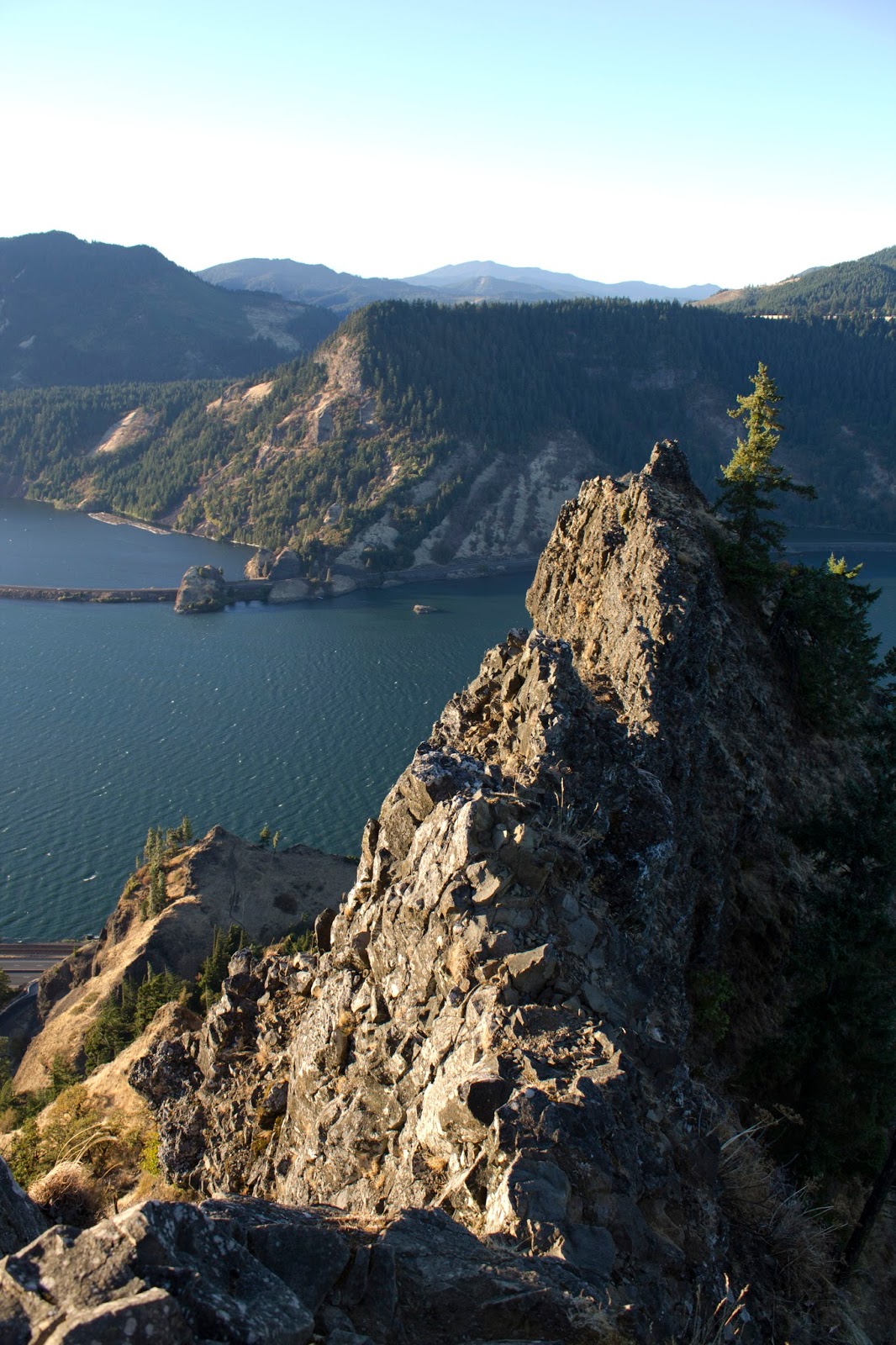
Do not bring dogs or kids on this trail, this is one of the sketchiest sections you'll hike in this gorge. The trail plummets down several hundred feet on a knife edge ridge with short steep switchbacks and somewhat loose footing (especially in the middle, the worst spot). But if you can get down the really steep spot, the rest isn't too bad. Keep going down and the views will start to appear to the west, and eventually the canopy opens and you are out on the exposed rocky knife, and you can see
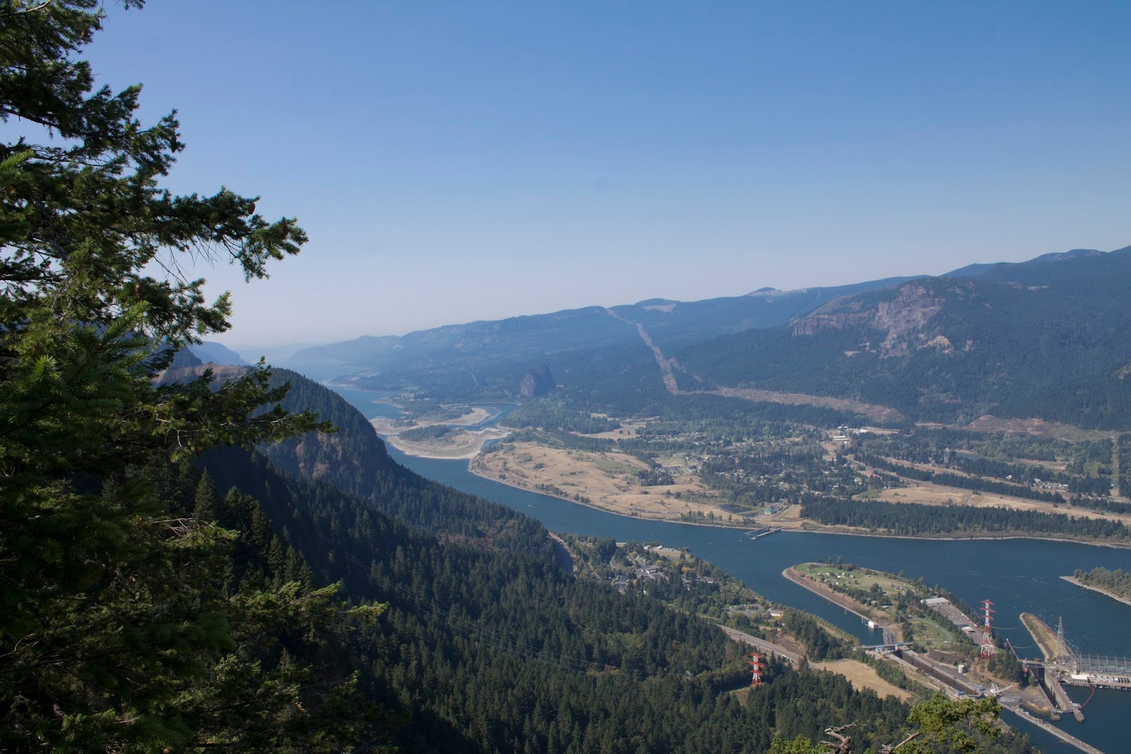
everything. From Munra Point on the very next ridge, to Cape Horn, Beacon Rock, Hamilton Mtn and Hardy Ridge, even Devils Rest if you lean far enough. To the east you can trace Ruckel Ridge up to the Benson Plateau over Eagle creek. You can see Augsperger mtn, all of Cascade locks and the Bridge of the Gods, so far below. You have an almost birds eye view of Bonneville Dam, and directly across from you is Table Mountain and Greenleaf peak. This is also the best view of the historic Table Mtn landslide you'll ever get.
 |
| The same can be said for the sign |
 |
| The only view from the false point |
 |
| Mt Adams from the false point |
 |
| Typical section of trail to Wauna Point proper |
 |
| First view Northwest, hints of what's to come |
 |
| Dangerous stuff |
 |
| West |
 |
| Beacon Rock looms |
 |
| Bonneville Dam below Hamilton Mtn (Left) and Table (top right) |
 |
| Mt Adams looms over cascade locks & the bridge of the gods |
 |
| Table mtn |
 |
| Wide shot northeast from the Point |
 |
| The Bunny Ears |
 |
| Mt. Rainier after some heavy editing to see through the haze |
 |
| Bridge of the Gods |
 |
| Buck Point! |
 |
| Table |
 |
| Mt. Adams imposing presence |
 |
| Aldrich Butte |
 |
| Beacon Rock - reminder it's 800ft tall |
 |
| Munra Point |
 |
| Keeley's panorama |
 |
| Dave conquers the point |
Soak it in, because then you gotta scramble back up several hundred feet on that damn sketchy trail back to the campsite, but after that it's a fairly easy walk back down to the car.
This is a solid hike. The only lungbusting climb is the scramble back up from Wauna Point, which isn't long. The trail offers a lot of distance and elevation without as much work as other long high hikes. It's also a great way to get some alone time. We could see people on top of Munra Point from Wauna, even though Munra is also "unofficial". Munra has been discovered by the masses, even Indian Point gets some traction, but Wauna...nobody goes here. I bet this spot gets 100 or so hikers a year. It's tough, but it's worth it if you can stomach the heights and the scrambling. I never felt too unsafe, never as bad as Munra, but it's definitely not for the faint of heart.