6 miles
1900 feet elevation gain
The most dangerous hike I've ever been on. Not a hike for the faint of heart, children, or dogs.
Munra point is a razor thin (by geographic standards) rock spine just west of Tanner creek about 1900 feet up.
 |
| Seen from Beacon Rock on Thanksgiving. It's the middle one with the exposed top ridge. |
There is no
official trail to the top, because the trail is not maintained by the forest service. This is mostly due to the rock climb sections that are not up to FS code. But make no mistake, this trail might not be officially maintained but it is absolutely there. This is a well trafficked hike by adventure types.
You can start this hike by parking in a spot next to the freeway and starting right at the bottom, but we chose to park at Wachella falls so our car would be in a better spot. If I ever do this hike again I'll probably park on the freeway, honestly, but let me explain why.
So you can park at Wachella, walk a mile west on gorge trail #400 to the base of Munra, Park at Elowah/Yeon Trailhead and hike a mile east on #400, or park off the freeway right at the bottom after Moffet Creek. We elected the Wachella run so we could get a more "legal" spot and a nice jaunt through the woods before the climb. Problem is, gorge trail 400 is not very well maintained and is very overgrown there were some beautiful flowers on the trail but you had to fight through patches of overgrown blackberry bushes. On top of that, you parallel the freeway, so you just hear cars the whole way. It was a crap trail.
At Moffett creek a little spur trail heads up into the woods with an ominous "Trail Not Maintained"
The funny part is, Munra's trail is in far better condition than the overgrown mess of 400.
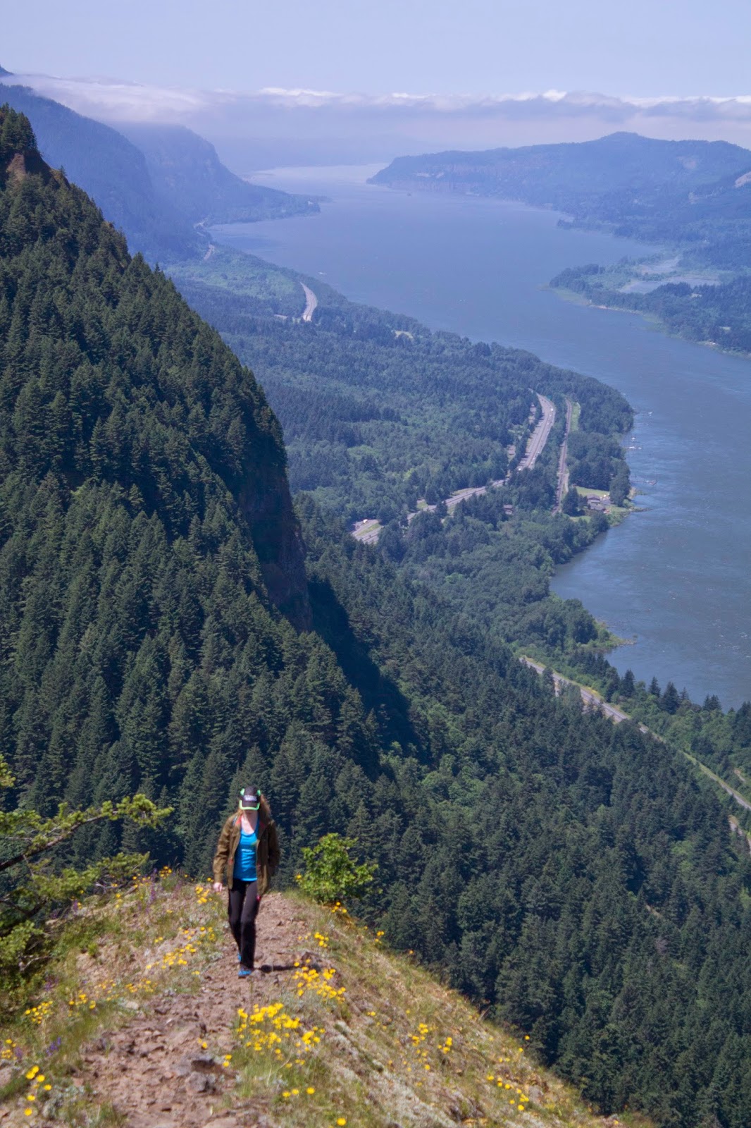
Here the climb begins in earnest. Not long before you are hiking up severe switchbacks. The guide I use told me to always take the lower path at junction points, since the junctions are actually just eroded washouts that some people use to cut corners on the way up. It didn't really matter which way we took, that trail was relentless all throughout the forested section. After the steep climb and some sore calf muscles we broke out into the open and got our first rewards.
 |
| Looking west from the first open viewpoint |
From here to the top (which was at least another mile) the climb was quite possibly the most fun scramble I've ever done. It was hand over hand climbing. The trail was rocky, just a beaten path on rocks, forever going up. It wasn't nearly as hard as the forested section since we frequently gained elevation not by walking but by climbing and using rarely used muscles for hiking. The trail follows a rocky ridge up the west side of Munra point, with probable death on both sides, but it's not too perilous as the ridge is wide enough for several people in most sections. There are some difficult climbing parts, but overall if you are in shape and don't act like a dumbass you'll be fine.
 |
| Your path. It's not quite as bad as the perspective makes it look, but not much better. |
Then you hit the final ascent. There is a section I've seen called the Gateway or the Gully in forums, and it effectively is the gateway to the top ridge. It's also a goddamn 20 foot wall of rock that basically asks you to climb it. It's a narrow channel between two bigger rocks with various handholds and a tree or two to hold onto. It's not easy.
 |
| Pic from Portland Hikers Guide user payslee |
But it's also fun. For now.
After the Gate, you are essentially on the spine, and things open up.
 |
| Facing west |
 |
| facing north. you can see the faint path along the ridge. |
There is a knob or nipple of sorts at the vertex of the 3 ridges, but it was occupied by people, so we climbed and sat on the back spine section instead pictured in the photo above. The spot you sat didn't matter, the view was incredible in all directions.
 |
| View west. The Portland Valley remains in clouds. |
 |
| Girlfriend on the ridge |
 |
| Better view of the spine we sat on |
 |
| Facing south. On the left is the Tanner Creek valley. |
 |
| The knob of Munra with some folks on it, facing north. Hamilton and Table flanking either side. |
 |
| Wildflowers and a view towards the river |
 |
| Bonneville Dam and Mt Adams being cheeky |
 |
| Table Mtn and Greenleaf peak beyond Munra's summit knob |
 |
| Wider view facing northeast. Visible is Bonneville Dam and Cascade Locks, and Stevenson, Washington. |
 |
| The "Path" at the top. Not pictured: the 100 foot fall of death to the left. |
 |
| Swift (I think) flying around |
 |
| The best picture I got of the bird |
We lounged on the top for a while, but then it was time to head home. & that's when the hike stopped being fun.
I've had a small fear of heights and ladders since an incident as a child. Not a bad fear of heights, but enough to get me a little nervous and I can't claim to be fearless. It was a talent show at an after school program I was in, maybe 4th or 5th grade. I was a stagehand, and on the sides of the stage were two ladders up to upper lofts. one ladder was bolted. The one on my side was not. But nobody knew that because it was a heavy metal thing that never budged.
During one of the performances I climbed up a few rungs and held on as I swung outward for dramatic effect, and it was just enough momentum to tip the ladder. Next thing I knew I was heading towards the ground and the heavy metal ladder falls on me. Adrenaline super strength kicked in and I was able to hold it back well enough to have it slide off my leg instead of crushing me. For a week the entire right side of my right leg was purple. But ever since then I've had a distinct issue with ladders. I can handle them, and heights, but if I think about it at all I easily psych myself out into a phobia. It's mild at worst, but it exists, and is the reason I will never ever try rock climbing. I know I wouldn't handle it well.
Of course that was basically what I had to do coming up, and now I have to go down. Going up is easy, you are looking up at your path the whole time. Going down, seeing what you are traversing and what a slip could mean, things change. I'm a tall guy, I have far to fall, and it just adds to the vertigo. The Gully/Gate was the worst. My girlfriend found the safest path down, and I managed it once I could see my handholds, but I never want to do it again. Ugh. From there going down was easier, but BRUTAL on the knees and my feet. I got lots of blisters on my feet and it just in general sucked.
We got back to the car early afternoon, drove to Cascade Barrel Brewing and rewarded ourselves with some great sour beers.
It was a great hike, but hell if I'm ever doing that again. I saw the top. No desire to climb that again. I satisfied my curiosity. One group of dudes brought a 10-12 year old kid. Whyyyyyy, THIS IS A BAD HIKE FOR CHILDREN
I saw a older couple heading up at the bottom with a small terrier. Whyyyyyyyyyy. THIS IS NOT A HIKE FOR DOGS.
Some photos from the trip down
 |
| Hamilton Mountain, our previous conquest. Looks like it wants to hug you. |


Cool post! Looks like a beautiful hike!
ReplyDelete