Day 2 began at 6:30 AM. The goal was to get to Hat Point as quickly as possible. We took nice long showers, had a delicious breakfast made for us by our hosts, and packed up. Made sure we knew our directions, and then we headed south back through the Imnaha canyon.
 |
| Imnaha |
 |
| Morning Canyon |
 |
| Going South to Imnaha |
 |
| (K) Imnaha River Canyon |
 |
| Imagine waking up to this every day |
 |
| You could live here and it would be cheating |
 |
| Horses on the hill |
 |
| Seriously look at that (looking south) |
 |
| The walls of the Canyon |
 |
| (K) Imnaha |
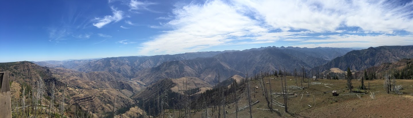
In the "town" of Imnaha, there is a road heading east labled for Hat Point. Hat Point is a lookout on Hells Canyon, the deepest river gorge in all of North America (Yes, including the Grand Canyon). Hat point is located at just a hair under 7,000 feet, and the Snake River that carved it is located just over a full mile below. Hat Point is a fire lookout in the central area of the canyon. It can only be accessed by a long 20 mile gravel road that winds its way up a 17% grade through the Imnaha river canyon and then on the plateau between the two canyons. I've heard some bad things about this road in guidebooks, and it seemed perilous. It ended up being alright. I guess I'm going to judge every single rough road I drive by the mess that was the road up Silver Star Mountain from June.
The road was slightly more than 1 lane, good, even gravel. Not incredibly steep most of the time, the real danger came from the lack of guardrail and obvious death if you went off the side. But that's nothing new to me, most wilderness roads in Oregon are like that. We were driving the road by 8am, and passed real, genuine cowboys right at the beginning. Soon after, we encountered cows. Lots of cows. Most of them moved off to the side as we drove slowly by, but at one point we must have separated a calf from momma because we ended up in a staredown with momma cow. After about a minute I started inching forward and eventually momma cow realized she wasn't going to stop a several ton SUV and she shuffled off to the side. Toyota 1, Cow 0.
After 7 miles you reach the top of the Imnaha canyon and you drive along the top ridge peninsula heading south. The scenery is completely different. In the bottom of the canyon it is a desert climate, dusty roads, tumble weeds, hot, dry. At the top of the canyon we were suddenly in alpine forest, tall evergreen trees and wildflowers abound. The drive is beautiful, though the trees block the views most of the time. Eventually there is a good viewpoint called Granny View Vista. You get to look at the Imnaha river canyon, the prairies beyond, and in the distance the Wallowas. Then the road turns east and north, and begins to parallel Hells Canyon.
 |
| Climbing Up Imnaha River Canyon |
 |
| Nearing the top |
 |
| Momma Cow having none of my shit |
 |
| Looking Southwest into the canyon |
 |
| Amazing, and this isn't the big one? |
 |
| Imnaha and the distant Wallowas |
 |
| Looking North West |
 |
| The road and car from the upper Imnaha overlook |
 |
| Imnaha Canyon North |
 |
| Wallowas way back there |
 |
| The Canyon's origin area |
 |
| Wallowas |
 |
| The top of the climb |
 |
| Add caption |
Hells Canyon was what Keeley was most excited for leading up to this trip, and the anticipation proved worthwhile. We finally got to Hat Point and walked to the edge of the cliff, and it was one of those moments when you really do get get kind of stunned speechless. The canyon is an absolute gaping chasm, and it's so deep you can't actually see the snake river outside one small section. We got an even better view from the fire tower, a full 360. To our east was the gaping chasm with a small bit of the Snake visible (With a boat in the middle!). To our north and west was the Imnaha canyon and the prairies. To our south west far in the distance loomed the majesty of the Wallowas, and to our south east was more Hells canyon, with Idaho's Seven Devils mountains looming over the gap. The Seven Devils rise from the Idaho side of Hells Canyon and are a bunch of scraggly peaks.
 |
| Hat Point Lookout Tower |
 |
| Hells Canyon |
 |
| Hells Canyon and the Seven Devils of Idaho |
 |
| The Snake River is in this picture, waaaaaaay down there |
 |
| The Snake River |
 |
| Hells Canyon |
 |
| Hat Point panorama |
 |
| Tiny boats in the upper left corner of the river |
 |
| Wallowa Lake area with Zoom Lens from Hat Point |
 |
| Hells Canyon Panorama |
 |
| Hells Canyon |
 |
| Keeley & Hells Canyon |
 |
| A silly attempt to pose |
 |
| beard |
 |
| Our road in, Wallowas way in the distance |
 |
| Hells Canyon |
 |
| Hells Canyon |
 |
| Hat Point |
 |
| (K) Feet |
 |
| (K) Selfie |
 |
| Trees in the way |
 |
| How Hat Point got named |
 |
| The rock says "Elevation 7,000 feet, Snake River 1250 feet. so think about that when you see the snake river, over a vertical mile below where I took the pictures from. |
 |
| One last panorama |
We took in the view for a while, but there wasn't much to hike and we were eager to get back down the road before more people started driving up. There was a campsite up here, an idea for the future. This would be one hell of a place to watch a sunrise/sunset. On our way down we encountered no cows and only passed one car. We had to stop and park several times to let the brakes cool. When we got back to Imnaha we had a choice to make. Take the somewhat sketchy forest road shortcut up to Zumwalt Prairie and the Buckhorn viewpoint? Go back to Joseph, then take the longer, better road up to Buckhorn (Still 30 miles of gravel)? Skip Buckhorn, drive south to the Hells Canyon overlook below Joseph? Or just stay in Joseph and chill out? Well, we decided to chill in Joseph. Last year we'd spent so much time driving on the coast, and we didn't want to do it again. I actually kind of like driving long distances to see things, but it had taken us all morning to see Hat Point and most of it was driving. We had a big backpack ahead of us, I figured we should rest up and relax before it hit.
 |
| Church in Imnaha |
 |
| Driving back to the Wallowas |
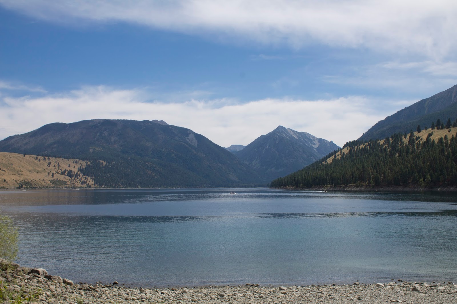
We drove back to Wallowa Lake and found a good, short hike to instead pass some time. We took the Chief Joseph Trail to a really neat small canyon on the West Fork Wallowa River, then went back onto the East Fork Wallowa River and saw a pretty waterfall. Then we put on our bathing suits and went for a swim in Wallowa Lake. A solid, nice relaxing afternoon. Then we packed up, drove to Enterprise, went to Terminal Gravity Brewing again, and ordered lots of pasta. Gotta carbo load for our adventure tomorrow. Then we drove up to Lostine and headed down the long road to the campgrounds near our designated trailhead. It got dark fast as we entered the Lostine river valley, and the road went from pavement to solid wide gravel to single lane really rocky crap gravel. Still not Silver Star, but worse than Hat Point and very unpleasant to drive. It was also insanely creepy.
 |
| A Statue in Joseph. I call it "Beefcake Cowboy with Dog" |
 |
| Joseph has a lot of cool bronze sculptures |
 |
| Chief Joseph, legendary leader of the Nez Perce tribe. Town name sake. Lets put a statue of him right next to a speed limit sign, that shall truly honor his memory. |
 |
| Wallowa Lake from Joseph's shoreline |
 |
| Wallowa lake pano |
 |
| Cool West Fork Wallowa river canyon |
 |
| Hi there |
 |
| Wallowa lake |
 |
| Little waterfall |
 |
| Our campsite for the night |
 |
| Messing around in the gift shop |
 |
| (K) lake |
 |
| (K) Lake Pano from river trail |
But, after getting creeped out for a while (it took nearly an hour in the darkness to get to the trailhead campground) we found a spot in the Shady campground, quickly set up the tent, and attempted to sleep. Tomorrow we'd just have to pack up, drive 1/10th of a mile, and go.


No comments:
Post a Comment