Last time I was at Mitchell Point it was spring of 2014. I've wanted to go back a lot, but haven't gotten the chance. Mitchell point is a fairly short hike an hour from home right next to Hood River so it was hard to justify the drive. But Keeley was coming in from a business trip on Saturday at noon, and the airport is on the way to the gorge, so we decided I'd pick her up, she'd change in the car and we'd just go straight to hiking.
Well, her plane was delayed, but the plan was on. However the trip and travel issues took its toll on her, so halfway through the hike she decided to head back to the car but insisted I keep going so we didn't make the drive for nothing. I felt pretty bad but decided to go up anyway because we are never in the gorge in late hours and Mitchell Point is a great western viewpoint.
Last time I did this hike it kicked my ass, which was embarrassing. Mitchell Point is only 1200 feet up, and even if you do the little spur to lower Mitchell point you only gain about 1300 feet on the hike. However last time I wore jeans and long sleeves to protect against the Poison Oak, so I blamed it on that. Don't hike in jeans. This time I was determined to be smarter, so I wore my thin swishy pants that have served me well this summer. They are light and protect my legs from the overgrown underbrush. I also have a new trekking pole! 30 Bucks at REI got me a single solid trekking pole with a screw joint up top to make it a monopod for my camera. So I figured I'd make it up the hill no problem this time.
Mitchell still kicked my ass, maybe this hike is just deceptively hard. I'll chalk my failure this time up to not eating well prior to the hike, but still, this is a hard hike. I guess that it makes sense, while Mitchell is only 1200 feet up you gain that elevation in just over a mile, so that's about a 1 mile/1k feet ratio, which is hard no matter what.
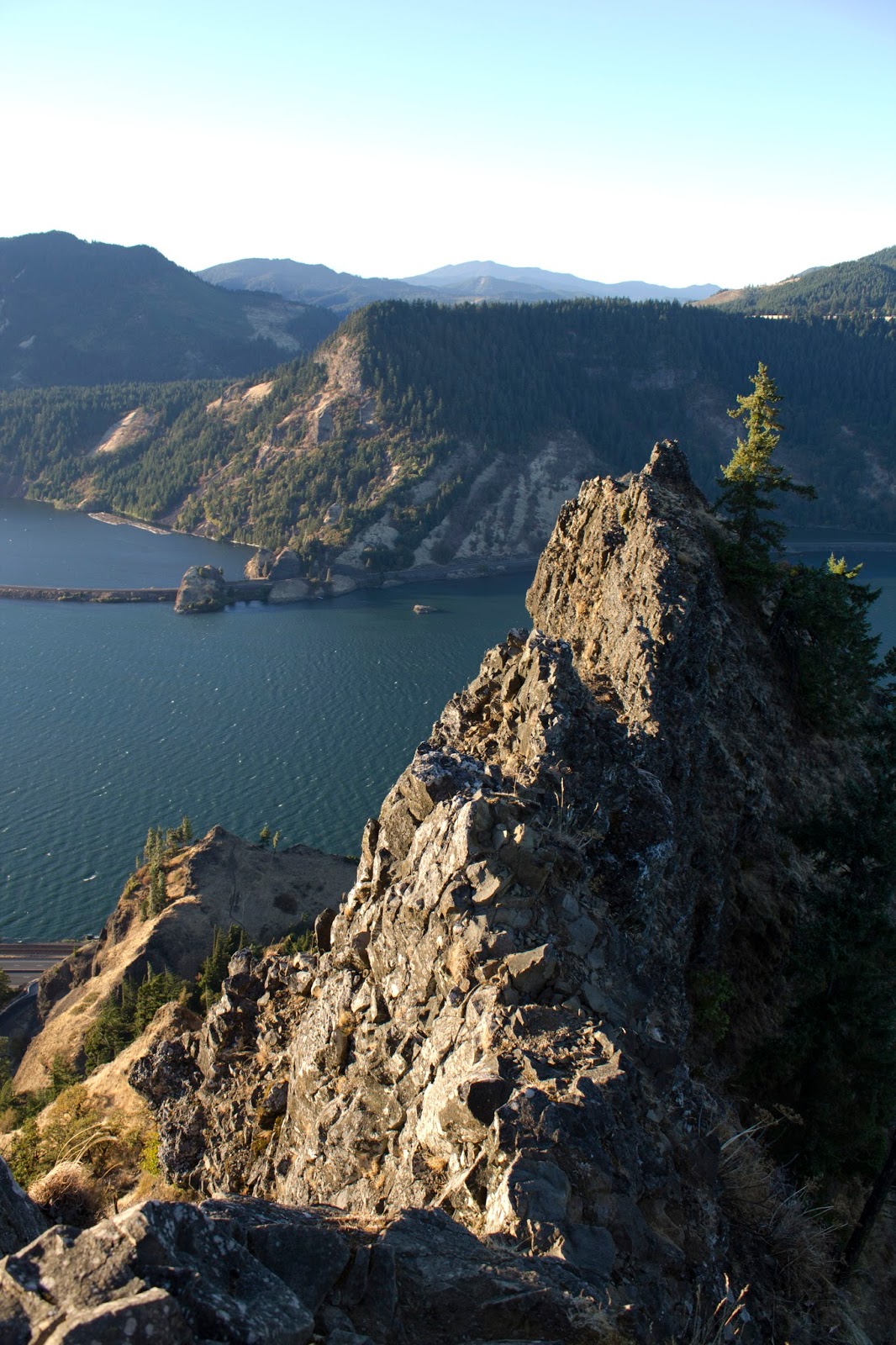
Mitchell starts in a mostly abandoned parking lot. Nobody comes here, it's too far for Portlanders and it only has eastbound access so Hood river folks have to go past it and turn around. Far above the parking lot looms Mitchell's knife edge, similar to Wauna point but lower and more dramatic. The trail leads up from the parking lot gently, passes a few other trails (There are former trails here that lead to Wygant peak, but they have not been maintained and are overgrown with Poison Oak now. I want to hike them, but i'll need to take care that day and I'll probably do it alone).
The trail goes from 0 to 60 .1 miles in and the steepness doesn't relent for half a mile. a quarter mile in there is the Spur trail to lower Mitchell. This is where Keeley gave up, and she hung out in the sun in the grass as I continued on. The trail crosses a big open scree field that is very hard to walk on and the trail sorta vanishes thanks to frequent rock tumbles. After half a mile the trail settles into the forest for another quarter mile and gets easier, goes under the powerlines, then the final difficult climb on the open ridge up to the death point at the top of Mitchell point.
I was alone and was treated to a wonderful sunset. I was able to see the Parking lot and told Keeley (Now back at the car) to go out and look up. She was the size of an ant, but we saw each other from 1000 feet away. I snapped my photos and ran back down the hill to catch the sunset at a lower angle. She was sleeping in the car, so I snuck off to the remains of the old historic highway to snap more photos. Driving back in the darkness kinda sucked, but I never get good gorge sunset photos, so this was great and I don't regret it.
 |
| Looking west from the lower Mitchell Point viewpoint |
 |
| Table Mountain way in the distance |
 |
| Keeley lying in the grass |
 |
| Keeley from the top of Mitchell Point, this is all the way zoomed in, she is the person on the little island of grass |
 |
| The exact same view, no zoom. Better sense of distance and scale. |
 |
| Looking east |
 |
| North and Mitchell Point |
 |
| Sun going down to the east |
 |
| Left is Dog Mountain, Right is Cook Hill. The one named "hill" is actually taller. |
 |
| Dog mountain and the west |
 |
| West |
 |
| Trail along the power lines |
 |
| Mitchell Point's spine from the power lines |
 |
| The trail |
 |
| Sun from the parking lot level |
 |
| The remains of the old Historic Highway, plus Dave shadow |
 |
| Where the highway got blasted off |
 |
| Facing west and the blasted section |
 |
| Stonework from the historic highway still remains |
 |
| Goodbye sun |
 |
| Add caption |
 |
| Sailing into the abyss |
 |
| Mitchell Point from where Keeley was standing looking at me. |
 |
| The trail up Mitchell |


No comments:
Post a Comment