As far as hike names go, the elevator shaft is probably the most bad ass name of every single hike I've done. I can't think of anything that sounds half as cool as "The Elevator Shaft". Maybe Starvation Ridge. Eagle cap is good too. But seriously...The Elevator Shaft. It's the best. At least until I finally hike Mt. Defiance.
I've had the shaft on my radar for a long time. I've always been a little intimated by it, for reasons that should be clear as I describe it. I've been bugging Keeley to go with me for about half a year now, considering it a training hike for St. Helens (Which we are once again signed up to do). Keeley seemed less enthusiastic. Well, she flew home to Cleveland to run a race, so that meant DAVE SOLO HIKE, and if she didn't want to go, well then screw it, I'm doing it.
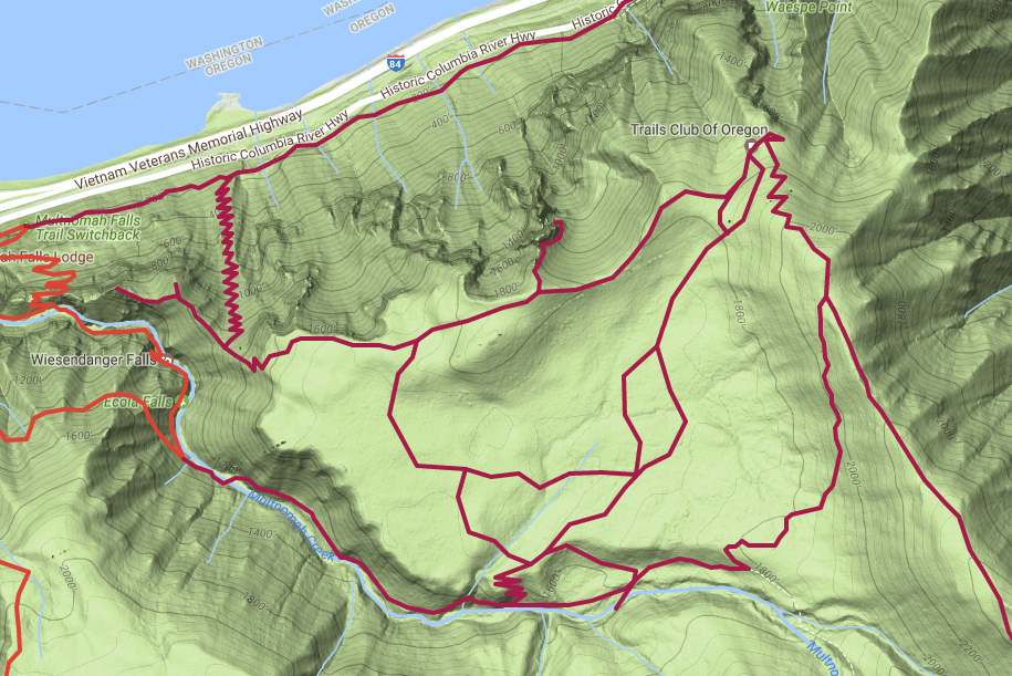
The Elevator Shaft (Also known as the Fire Escape) is a gigantic 1,000 foot landslide tucked basically right next to Multnomah falls. It's an old talus slope, the kind most trails in the gorge cut across. But it's literally taller than most buildings in the world. The total elevation of the shaft is around 1,150. The Empire state building is 1,250 feet tall, for reference.
The unmaintained, former trail goes up the entire thing until it ends in Multnomah Basin, which has it's own adventures. For now, I just wanted to reach the top. I was leery of the trail for a number of reasons. Besides the whole "climbing on a giant landslide" thing, I had no idea how stable the footing would be, how steep the incline would be, I have read a few trip reports of how hard to find and confusing the basin is once you reach it. I've also heard the occasional rumble of cougars. Cougar attacks are extremely rare and from what I've read chances are they've already stalked me on trails a few times, but they almost never do more because we are big and not worth the hassle. I'm 6'4, carry a large backpack that makes me look broader, and a have big stick with a metal end, so I'm probably not worth attacking, even solo.
Whatever, if I die, at least I go out doing what I love, being mauled by a cougar in the middle of the woods.
The trail to the shaft is off the Multnomah falls path, at the first major switchback. 1/4th of a mile later and you reach the base of the slide. The "trail" starts on the far east side, right before the corner. From here, your life for the next hour consists of walking up rocks and switchbacks. Some say the total number of switchbacks equals about 100. I only counted 64, and that was being generous with the definition of switchback.
 |
| The unassuming start of the Elevator Shaft trail on the left. |
 |
| Looking up at the day's work. Note that the top 2/3rds of the shaft are actually located above the trees. |
I shouldn't have been worried, it was more fun than anything. The trail is pretty easy to follow most of the time, the rocks are pretty stable, and the incline isn't that bad. If I fell, I'd tumble 10ish feet and get hurt, not die. Probably. It was more fun to climb than expected. Because the rocks require your complete attention, you move slow and methodically, and I never felt too winded, despite climbing 1000 feet in less than a half mile. I never even took a sip of water on the entire shaft. The shaft starts out in rocks, climbs through a brushy section, then climbs a lot more rocks, before vanishing into the woods to the right. Once you hit the woods, the unmaintained trail is actually in great shape.
 |
| From switchback 45 |
 |
| Slugs getting freaky on switchback 53 |
 |
| Near the top looking down |
 |
| The top of the shaft. Note the same two trees from above, further below |
From the top of the shaft trail it hits a junction with what I'm calling Multnomah Ridge. Right, and down the ridge, is a viewpoint. To reach that viewpoint, you must climb out on an exposed rock spine. It's cool, and only one side is certain death.
 |
| Multnomah Spine |
 |
| The spine, looking south, upstream |
 |
| Mult creek, far below the death chute |
After taking in the disappointing viewpoint, you head back up the ridge, and the real fun begins. The Elevator shaft is not the hardest climb on this hike. The next 800 foot wooded section up to Multnomah Basin is. It sucks. But after you power through it and gain the basin, it's worth it. The basin is quiet, serine, creepy, and beautiful.

The path meanders along the edge of the cliffs for a while, joins up with another trail at the"Cougar Rock -Shaft Junction", which shall be important later. From here I was looking for a path off to the north cliffside. A viewpoint of Cougar Rock exists somewhere around here. Sure enough, I found it. The trail splits (No signage) and then gets reeeaaaallly sketchy. The trail to actually see Cougar Rock is sketchy as hell, and I'm legit surprised I mustered the nerve to see it through (Curiosity is a powerful drug, I suppose). You have to duck down a major rock gully next to this giant rock formation, straddle a thin line downhill, round a corner and sit on a rock with enough space for one person. Cougar Rock is really cool, but after a quick break I got the hell back up out of there. No desire to go back to that spot. The view was good, but not
incredible or anything. Twas a checkmark on my list. On the way up I found a pair of glasses on a stump. Seems like a bad thing to lose.
 |
| The trail out to Cougar Rock |
 |
| The "trail" to Cougar Rock |
 |
| Hardy Ridge, Hamilton, and Table |
 |
| Cougar Rock |
 |
| This stump is a NEEEERRRD |
From here I traveled easterly again, and found myself at Nesika Lodge. A private lodge hidden in the woods run by the Trails Club or Oregon. They don't mind hikers puttering around though, and on the far side of the campground was a huge surprise: Bickel Point. An outstanding viewpoint, facing east, like a zoomed in version of the Crown Point view.
 |
| Nesika |
 |
| Bickel Point |
 |
| Yes, I used a Selfie Stick and yes, I liked how it turned out |
Now, with my 3 goals completed for the day, 5 miles in, and it being only 11:30am, Stupid Dave kicked in. I could take the Multnomah Basin Road from the lodge back to my car. OR...I could explore every little side trail in the area first! guess what I did. Yeah.
First up: Climb the ridge from Nesika up to my good 'ol pal
Franklin Ridge. I hit the junction, went back downhill to the Lodge. Lodge visit #2. Then I headed west on the road. But quickly I saw a side trail. Took it, because I knew it would lead back to Nesika on a side trail I saw coming in from the Rock. The trail had a cute gate on it. Nesika Visit #3. Back up the trail to the road. From here, I took the road all the way back to the Larch Mountain trail, sat on a bridge over Multnomah Creek, and looked at my map.
 |
| The gate to Nesika |
 |
| Yay Nesika! |
I
could head back from here.
ORRRRRRRR I could walk back and take one of many more side trails I saw on the road, that I skipped, so I could stay oriented. But now I knew the basin, and wasn't afraid of getting lost (None of these basin trails are on maps, by the way, not even the road). I walked back up the basin road, took the first sidetrail, cut right to avoid the shortcut downhill, and then walked a long way back. On the way I came across what I will call the "Cougar Rock-Mult" junction. From there, I went back to the Cougar Rock-Shaft junction. Now I had a choice: Head back the way I came and explore that way, or head
back to the lodge again, and hit all the trails on the way back home. I chose the latter. I refused to leave a trail un-hiked, nothing bothers me more than unfinished business on a hike.
 |
| The Basin Road |
Nesika Lodge visit #4, back on the basin road, took the side trail, which turns out to be a nice shortcut, then a second side trail, which takes me back to the Cougar Rock -Mult junction. Then I went back to the road, took the shortcut down to the high water trail...and from there I went back to the car, dropped the glasses I found off at the Multnomah lodge, got back on the highway and blasted Quadrophenia all the way home.
14.5 Miles
roughly 2000 feet elevation gain
The entirety of Multnomah basin has now been explored.
Badassery accomplished.
 |
| The lower section and shaft on google earth |
 |
| The basin from farther up |
 |
| Everything in the middle is what I did |