
 |
| Ruckel Ridge and Eagle Creek Canyon |
I've been thinking about this hike for years, since I first found it on the Oregon Hiker forums and read the description. Since that day I've built the hike up in my mind as a mythological beast, to the point where I've actually chickened out on it multiple times. Including two weeks ago, when I prepared to finally take it down, only to have Keeley bail early due to stomach issues and then I turned around right afterward because I stumbled directly into a poison oak bush and panicked. I didn't get Poison Oak, but this was my closest call thus far. The plant literally brushed my face. I'm either still immune or managed to clean myself off properly.
With renewed vigor I decided that I would try again.
THE GOAL
Climb Ruckel Ridge, see why it is mildly notorious among "in the know" hikers from the area.
Finally, finally, actually stand on the Benson Plateau, a gorge geography landmark.
Also explore the Ruckel Creek trail, I guess.
THE PLAN
Get up early because it was expected to hit the low 80's by the afternoon. Get to Eagle creek, go up Ruckel Ridge, see all the ridge stuff, reach the Benson plateau and the top of Ruckel Creek, come back down Ruckel Creek, take the historic highway the last half mile to the car. A true loop, at no point did we tread the exact same path.
THE TRIP
I want to start this description off with some quotes. When you google Ruckel Ridge, these are the opening lines describing the hike.
"Ruckel Ridge. The Ruckel Ridge. Widely recognized as the most treacherous day-hike in the Gorge, this is not a climb for inexperienced hikers, dogs, or children."
"Ruckel Ridge is one of, if not the most challenging and difficult of day hikes in the gorge"
"This is the most exciting hike I've ever had the pleasure to do in the Gorge. I would not recommend it for kids, anybody out of shape, people who fear heights, dogs, or for a rainy day trip. "
"This is about as difficult as a hike can get before it has to be called something else."
Maybe now you might understand why I'm proud to have conquered this bad boy.
Ruckel Ridge is a ridge starting near Eagle Creek's mouth,, and goes in a long, slow southeastern turn up to the Benson Plateau. It is a knife edge of a ridge; narrow, rocky, and steep. It contains many sections where you have to climb using your hands.
I've reached Ruckel Ridge twice before. Once by myself on a scouting mission past Buck Point, and once with Keeley for funzies. We climbed to the beginning of the ridge where a nice overlook gives you a view of the Bonneville dam. It probably wasn't even more than a couple of miles round trip to the overlook. This time was to be different. This time, I was gonna go the whole way.
Getting to Buck Point is easy. Park at Eagle creek, walk up the 400 trail to the Eagle Creek campground, find the buck point sign at the back of the campground, travel up about 10 mild switchbacks to the power lines, and bam, semi-okay views. The real fun starts here.
 |
| The base of Ruckel Ridge and Eagle Creek Canyon |
From Buck Point follow the obvious trail back into the canyon down a short hill. Ruckel Ridge is technically not an official forest service trail, so it's not on maps and is a different sort of tread: rocky and loose. Once out of the short forest section the trail turns uphill through a talus field with slippery rocks. A massive bush of poison oak sits on the right side of the loose tread. I made careful not to hit it this time. Up this short but steep loose climb the trail heads back north through a much larger boulder field and then steeply up a root path to gain the ridge to the Ruckel Viewpoint.
 |
| The Dam |
 |
| View from the first Ruckel Viewpoint |
 |
| Check out that sweet cloud shelf |
 |
| Selfie before the fun |
 |
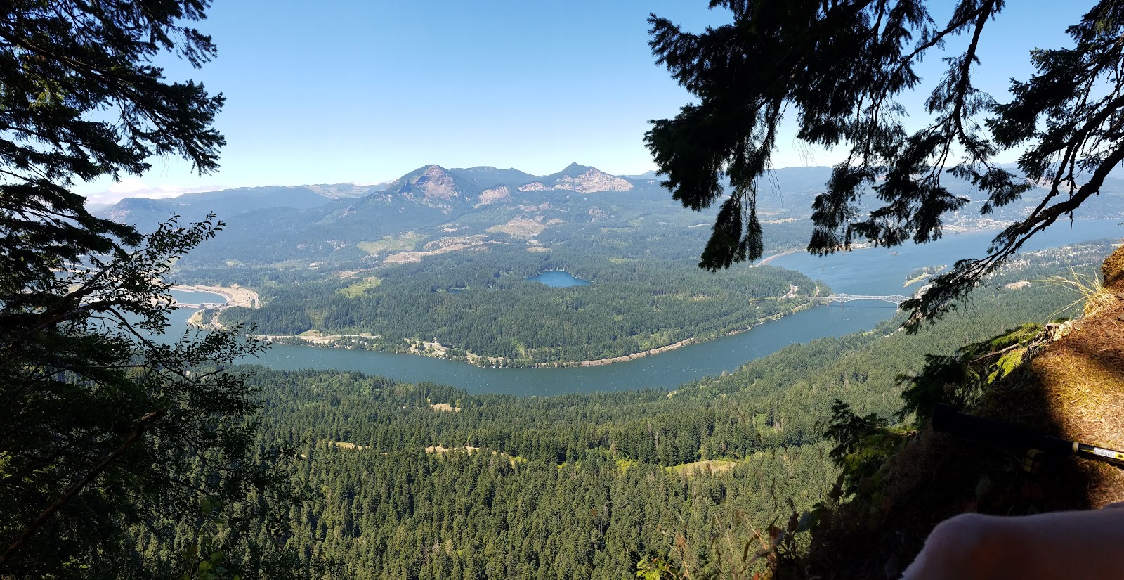
| Panorama from eagle creek canyon to the river, Wauna Point becomes prominent |
It's a great spot to rest and take in the views of Bonneville Dam. Congrats, the first hard part is over! The 3 miles from here until past the catwalk is probably the most fun trail in the gorge.
When doing research for this trail, I tended to see two kinds of descriptions by people who have hiked it previously. People who were THIS TRAIL IS VERY HARD AND VERY DANGEROUS and another camp of people that were like "The warnings are overblown, it's not that bad". It was impossible to tell which side I would agree with. Are the people saying it's overblown hardcore hikers with warped senses of difficulty? Were the people who claimed it was the worst thing ever normal people or just dumb tourists who weren't prepared for what they got themselves into?
 |
| Pillar on the early trail |
Turns out I fell on the latter category, the trail isn't as bad as some descriptions make it seem. Make no mistake, this is not a trail for kids or dogs in any way, but a reasonably fit adult can do this hike and enjoy it. There are bad spots but the trickiest spot (the Catwalk) has an easy bail-out path if you get spooked. Generally, for 3 miles past the first viewpoint, Ruckel Ridge is an incredibly fun hike. You get short steep sections where you have to climb rocks, maneuver through trees, and each step is fun. You are climbing, but it's so interesting that you barely notice the work, and the hard sections are usually pretty short. The ridge itself is very narrow, 20 feet wide before dropping off at it's widest, and about 5 feet wide before drop offs on average. People afraid of heights will not enjoy this hike at all.
 |
| Climbing up Ruckel Ridge |
Most of it is wooded, and there are several points where you don't stay on the ridge proper due to cool basalt rock formations that the trail navigates around. Most of it is forested, but you occasionally get views deep into Eagle Creek Canyon and even a view or two of Mt. Hood!
Since I had never actually done this trail before I kept waiting for The Catwalk, a notorious section of the trail that is a narrow rock spine that's tricky to navigate. At one point we thought we found it, but it turns out it was just a different narrow rock spine. I'll call it the Fauxwalk. It offered the best views on the trail, deep into the canyon to the south.
 |
| Mt. Adams |
 |
| Mt. Hood in the way distance through the mist |
 |
| Climbing up the ridge |
The Catwalk is pretty short and lives up to it's name. On one side is a 60 foot plummet to death. On the other is about a 20 foot plummet onto probably serious injury. The catwalk is a short series of about 3 rock spines that range from 3 feet wide to 1 foot wide. Honestly though, only one part is genuinely scary. You have to turn around and step down this one rock like a ladder to reach a lower section. I didn't take many photos due to fear of losing my balance and it honestly wouldn't photograph well, it's all very wooded in and hard to understand if you aren't there.
 |
| The Catwalk, not quite as bad as it looks |
 |
| As sketchy as it looks |
 |
| Dave for scale on previous photo |
Past the Catwalk is when the fun stops.
From here, after a short steep descent into a saddle, the trail begins the final half mile or so push up to the Benson Plateau. The rock climbing is done, the ridge is wider and becomes a steady uphill slog. It tests your will, because on first try we had no idea how much climbing we had left to do. There is one semi-decent viewpoint about halfway through this god-awful slog, a great spot to take a breather and fuel up for the final push.
 |
| Less happy selfie during the rough part |
 |
| Tanner Butte and the Eagle Creek Valley |
Then all of a sudden, it stops climbing. A busted up old sign marks the start of the Benson Plateau. I was finally on the Benson after all these years. It's a big flat plateau at about 4000 feet, formed by the Herman and Eagle creek drainages. It is just a lot of pretty woods. Fantastic atmosphere.
 |
| Panorama of the Benson Plateau. I take a lot of pictures of the sights, but this in between stuff in the woods is what makes a lot of hiking so magical |
 |
| A Dave in the woods |
 |
| Ruckel Creek |
 |
| Found the way home! |
We didn't stay on the Benson long. The trail drifts downward to cross Ruckel creek, then back up the other side where it joins the Ruckel Creek Trail, which is an official trail! Now our long descent began.
The Ruckel Creek trail is a terrible trail. It's terrible. It reminded me of the Wyeth trail in that it lacked charm and was stupid steep. I think Ruckel Ridge is actually easier, because Ruckel Creek is built to forest service standards, which makes it boring and dull as well as a long slog uphill. We were going downhill, but it was still stupid steep and bad. Also, it is poison oak city. I've never seen so much of the damn stuff.
About a mile and a half down from the top the trail finally sees something interesting when it levels out for a mile and passes through multiple major hanging meadows. Decent views, probably would have looked prettier a month ago when the flowers were still in bloom and it wasn't so hot. We couldn't linger, the sun was oppressive. You do get to look at Ruckel Ridge on the other side of the creek valley, and it's amazing seeing what you just climbed.
 |
| Ruckel Ridge is the foreground ridge |

 |
| Meadows |
 |
| Meadows |
 |
| The Gorge from afar |
 |
| Ruckel Ridge in the foreground |
The trail then starts going down steep switchbacks again, and you get the best view of the day, a look directly across the river to the Table/Greenleaf slide. It's a perfect perspective.
 |
| Cascade Locks |
 |
| Bridge of the Gods |
 |
| Mt. Adams |
 |
| The evidence of the Table landslide and how it jammed the river is very obvious from here |
 |
| Table Mtn |
 |
| The Table Mountain Landslide |
 |
| Walking down Ruckel Creek |
 |
| The entrance to Ruckel Ridge from the historic highway trail |
 |
| Dirt tan! |
9 miles, 3900 feet of elevation gain
I actually don't know if this is the hardest hike I've done in the gorge. Or even the one I'm actually most proud of. My body still aches, but nothing Ruckel Ridge offered was particularly more extreme than other hikes I've accomplished. It was everything I expected and hoped, and somehow still less.
-Munra Point had more dangerous exposure, especially since the catwalk is skippable.
-Rock of Ages had steeper and more perilous climbs, better view points, and similar challenge
-Wyeth, Casey Creek, and other hikes might be more difficult. Casey Creek still feels like the hardest challenge I've overcome.
The one thing Ruckel has that other hikes don't is consistent fun for as long as it does. Rock Of Ages is super interesting for a mile, then becomes a slog. Ruckel Ridge, from parking lot to the saddle past the catwalk, is the most fun gorge hike possible. Other hikes might have funner parts, but nothing as consistently enjoyable or interesting as those first 3 or so miles.
The rest of the hike, outside the short stretch on the plateau, sucks. Ruckel Creek trail has three interesting sections (Indian Pits, Viewpoint switchback, and the meadows), all short, all generally not worth the trouble. If that trail was better, I might be inclined go to again soon, because those first 3 miles are so fun. If I go back, I'm going to do it on a cool, dry day. The heat got pretty rough towards the end, but I don't want my path to be slippery.
It was a worthwhile adventure and I'm honored to have done it. From here, Mt. Defiance stands as the last great notable Gorge day hike I have yet to conquer. Sometime in the next two months, I'm going to have to try it.
STRAVA DATA


No comments:
Post a Comment